Hiking Cambria and San Simeon
Hello! It’s a pleasure to have you here on my page dedicated to Hiking Cambria and San Simeon. I want to share with you my FIVE FAVORITE NATURE WALKS either along or near the local beaches here. In presenting these details to you, I am absolutely thrilled to be sharing some of my most cherished outdoor spots. I think you, too, will appreciate the stunning beauty and awe-inspiring nature of these locations as much as I do. All the trails here are beautiful year-round! Even though this is my Real Estate website, it’s important to mention that you won’t find any beaches or trails for sale here, as I am here to help you find the perfect home and not the perfect trail! (See samples of previously listed homes.)
Jennifer's Top Five Favorite Nature Walks
I am excited to recommend some extraordinary nature trails where you can visit beaches and walk or hike in locations around Cambria, San Simeon, and beyond. Trust me, these locations are worth your time and energy, and you won’t want to miss the opportunity to spend some time outdoors and immerse yourself in the breathtaking beauty of this area. There are so many beautiful walks on the Central Coast. (See the bottom of this page too for more links and galleries.)
Hiking Cambria, San Simeon, and Big Sur
Included below are four walking/hiking trails within 10 miles of Cambria, and one walk a little further north in Big Sur. Every season has its own beauty in these walks. Even certain times of the day can make them seem so unique and majestic. You will see Egrets, Herons, ground squirrels, and sometimes snakes and salamanders. Each has its distinctive characteristics and unique flowers and trees. I would love to hear about your favorite walking and hiking trails and what you found captivating. Maybe one of these five places is your favorite, or a different beach or trail somewhere in San Luis Obispo County.
Fiscalini Ranch Preserve (East/West Ranch)
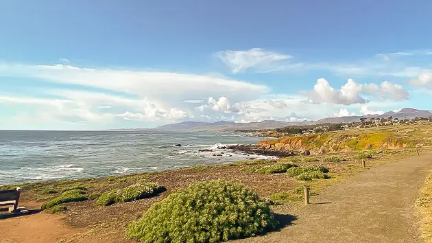
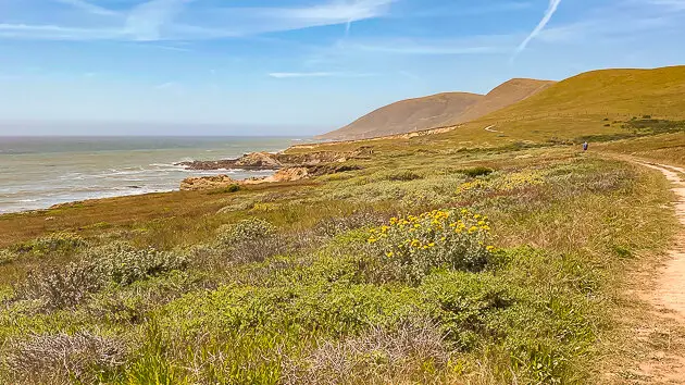
Cambria’s Fiscalini Ranch nature trails are between Otter Cove and Marine Terrace.
The Monterey Bay National Marine Sanctuary
Wildlife, Signs, and Benches
The Fiscalini Ranch Preserve, also known locally as the East-West Ranch, is first on the list here. This is one of my all-time favorite walks. From season to season, the beauty of the preserve changes a lot. The various trails here offer many hiking options, running along the south end of Cambria’s coastline and into the Pine forest. Along your walk, you may see several endangered species and, at times, the migration of whales along the coastline. Sometimes these whales are very close to the shoreline and have even come into a local surf spot at the south end of Moonstone Drive. They have also been seen swimming near the pier, further north in San Simeon Cove.
This meandering ocean bluff trail is accessible from both the south and north ends of the Ranch. There are many ranch openings: You can start on the Marine Terrace (Windsor or Marlborough) or at the Ranch trail entrance up on Lodge Hill (on Trenton or Tipton Streets). Park Hill has two openings: One below on the bluffs on Windsor Blvd and one on the upper bluffs on Huntington Road. The trail is more than a mile along the shoreline, and numerous people enjoy this walk daily.
See these off-site links for maps and guides to trails and parks in the Cambria area.
There are Monterey Bay National Marine Sanctuary signs at the main north and south entrances that give you an idea of what is to be found here. There are shorter and longer walking routes, whichever you prefer. If you are interested in sea otters, stay on the lower bluffs and watch them in Otter Cove on the south end. You might even see a weasel on the lower Ranch! Along with migrating whales, you may see elephant seals, deer, squirrels, foxes, California Condor, and many other species of birds.
You can also hike up into the woods on the Forest Loop Trail. Many benches are scattered throughout the Ranch to watch for whale spouts, dolphins, or other interesting sights on the ocean and in the woods. Don’t worry about getting lost because you will always be aware of the ocean, and it will guide you.
- Cautions here include possible sightings of Mountain Lions! It is recommended that women not hike alone through forested areas! Also, there is a maximum danger alert for swimming in the ocean, back at the Shamel Park Beach area. The shoreline beach break has an extreme undertow; most people are unaware of it, and you can easily be knocked down by shore break beach waves and dragged out into the undertow!
William Randolph Hearst Memorial State Beach/San Simeon Cove & Pier
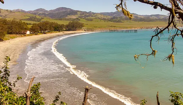
The Beach Cove at San Simeon is off of HWY 1, across from the Hearst Castle Tour entrance.
The William Randolph Hearst Memorial State Beach/San Simeon Cove & Pier is a remarkable walk! It almost feels like you’re in a different country, perhaps somewhere in the Mediterranean. Exploration here offers many variations. Having snacks or a picnic lunch here is a great idea, as it is possible to walk up to two miles round trip ~ your choice! This amazing beach walk starts at San Simeon State Park on the beach, at the Cove, just north of the pier.
As you walk about a quarter-mile north up the long stretch of sandy beach, you will then take a small path to the right just as you finish passing the Hearst Ranch winery buildings. Go up the little trail that leads up and off the beach (to the right), through the ground-cover ice plant, up to the bluff, and then through the eucalyptus tree trail leading out to San Simeon Point. When you are out at the end of the point, walk a little further to the north, and this will take you through the “Cathedral of Trees,” ~ a beautiful canopy of Cypress trees.
Adventure, Secluded Beaches, and Picnics
If you’re feeling adventurous, take a path off the main trail to the ocean bluff and find a secluded beach to rest and picnic. Some of these little beaches have exciting caves to explore. Couples and friends enjoy a bottle of wine together, with spectacular views and a secluded environment. SIDE NOTE: A few (hopefully) harmless naturalists like to go “au natural” out here – just letting you know you may see more than you want to on this walk.
- Some of the cautions and dangers here include Elephant seals that bite! Do not swim with them, pet, or go near them—especially if females have their young pups with them. This includes being in the water or on the beach. Dangers include loose rocks at specific cliff areas—and possibly falling trees when it’s windy (Pine & Eucalyptus).
- Poison Oak thrives here, and leafless stems can also transfer oils. You will even see full-size poison oak trees. Hazardous danger warning here for little children running to and fro, if they venture off into the poison oak leaves. One further note: you should not attempt to Kayak to the bell buoy off the end of the beach point. Strong winds can be hazardous to kayakers here, making it difficult to return to the beaches.
San Simeon Campground Washburn Walk
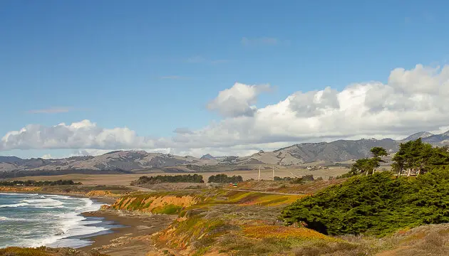
Washburn Walk trail is just North of Cambria, before the San Simeon Creek Road turn-off.
The Washburn Campground Trails (just north of Cambria)
You will find this turnout just north of Oceanpointe Ranch & Dauo Ocean, adjacent to San Simeon Creek Campground (Washburn Primitive Campground). The parking spot is at the Washburn Campground Day Use Area, across the highway from the beach access (Dirt Lot). This is an unusual walk, with its varied terrain and unique wildlife. I have seen bobcats, turtles, and plenty of birds on this unique walk! Park your car in the daytime parking lot, on the east side of Highway One – just past Daou Ocean (formerly Centrally Grown).
Wooden Boardwalk, Natural Marsh, and the Woods
Hop onto the wooden boardwalk – it turns into a dirt path; follow it across the marsh bridge and up and through the woods. Stay on the pathway, as there can be a lot of poison oak ~ depending on the season (spring and summer). Washburn Marsh Trail eventually descends through a crevice and crosses a winding, surreal bridge before ascending into the Washburn campground.
Once you are in the campground, you can end your hike or extend it by following other trails. To find your way back to your car, skirt the campsites to arrive at the parking lot. I’ve hiked the other trails here and eventually ended up back at my starting place, the car. Pack water! This hike is about 2.5 miles and can be extended for more adventures.
- At this beautiful location, some cautions and dangers include being aware of other drivers, locking your car, and avoiding swimming or surfing. Numerous seals have been found on the beach here with shark bite marks. Watching out for drivers on HWY 1 is an absolute necessity. Use extreme caution pulling off and onto the Highway 1 roadway.
Harmony Headlands State Park
The State Park access trail for Harmony Headlands is north of Cayucos on HWY 1.
The Harmony Headlands State Park Trail (4.3 miles north of Cayucos)
This location is just off Highway 1, between Cayucos and Harmony. You can park your car on the west side of Highway 1 in the designated lot. The trailhead here begins at the parking lot. If you are up for a longer walk, fast-paced hiking, or running, it is just over four miles round-trip. But this depends on how far you want to go once you get to the coast. There is no specific area here for hanging out on beaches, as it is mainly coastline bluff and rocky areas at the seaside. Bringing binoculars is a good idea, as you might spot an eagle or a mountain lion.
Walking or running all the way to the ocean
Grassy seaside trails will climax at the coast, and the view will take your breath away when you arrive! There are a few benches and many spots to sit and enjoy the beauty of the raw, rugged coastline! Be sure to take water, your camera, and an extra sweatshirt if the fog rolls in – even at the end of hot days.
- A big caution here is to lock your car as you park right off of Highway 1. And women should never hike alone here. The trail can be very secluded at times. Also, the HWY 1 hazard here is high-speed drivers and lots of unnecessary passing.
Sand Dollar Beach (Big Sur, by Plaskett Creek Campground)
Forty miles (1-hour drive) north of Cambria, off HWY 1, is where this astounding beach is located.
Los Padres National Forest – Sand Dollar Beach – Day Use Picnic Area
Incredible and an all-time favorite, Sand Dollar Beach (and Day Use Picnic Area) is situated on the west side of Highway One in Big Sur, about an hour north of Cambria. A spacious parking lot is across the Highway from Plaskett Creek Campground (on the right). I promise it won’t disappoint! Walking to the beach is not very far – about a half-mile. A footpath leads to a long wooden stairway that goes down the cliff to the ocean. Once you get down to the beach, you can walk north or south on the sand and find a sweet, private spot to spend the day.
Big Sur Rock Formations and Extensive Beach Walk
It’s Big Sur; therefore, there are many fantastic rock formations, jade stones, and colorful rocks on the beach. Depending on the time of year, you may see mostly sand or mostly rocks, depending on where you are. It is a beautiful beach where the kids can play in the water close to shore. Do pay attention, though, because when the tide is going out, a low-tide outgoing current is created at the south end of the beach. This occurs near the big rock in the water, where surfers at times use the tidal current to paddle out. It can be fast, like the escalators at airports.
- Some thoughts here about cautions. Lock your car, stay alert, and watch out for poison oak along trail edges. The danger alert here for hiking is: do not climb down loose rock or hazardous cliffs that are not trails. (People stuck while hiking have had to be emergency helicopter-lifted off of several cliffs in Big Sur.) And the main beach hazard here can be the outgoing tidal current that swirls out at the beach’s south end, on the enormous rock’s north side. This can be deadly for adults and children, so be sure to pay attention and watch those around you closely.
Thanks for viewing my Five Favorite Walks!
In conclusion, below is a complete listing of the vast offerings in our Cambria and San Simeon region. Similarly, these listed beaches, hiking trails, and parks can be viewed (with photo galleries) on the extensive website at VisitCambria.com. You can view the Cambria Chamber of Commerce. for more information about lodging, dining, businesses, activities, events, and more.
Have a wonderful day, and do enjoy the beaches, hiking, and trails!
Complete listing of Beaches, Parks, and Trails
- Click Beaches, Parks, and Trails for all their info, photo galleries, and much more.
BEACHES
- Harvey Street Beach Access
- Moonstone Beach
- Moonstone Beach Boardwalk
- Nottingham Drive Beach Access
- Pico Creek Beach Access
- San Simeon Cove & Pier/William Randolph Hearst Memorial State Beach
- Wedgewood Street Beach Access
PARKS
- Fiscalini Ranch
- Harmony Headlands State Park
- Lampton Cliffs State Park
- Leffingwell Landing Park to San Simeon State Park
- Lower Leffingwell Landing Park – Picnic Access
- Moonstone Beach – San Simeon State Park
- San Simeon Beach State Park
- Shamel Community Park
- Upper Leffingwell Landing Park – Access to San Simeon Creek
TRAILS
- Berry Trail
- Bluff Trail
- Burton Drive Trail
- Creek to Forest Trail
- Creek to Ridge Trail
- Fern Canyon Henry Kluck Memorial Trail
- Fiscalini Ranch
- Fiscalini Ranch – East Village Entrance
- Fiscalini Ranch – Marlborough Entrance
- Fiscalini Ranch – North Entrance
- Fiscalini Ranch – Rodeo Grounds Entrance
- Fiscalini Ranch – South Entrance
- Forest Loop Trail
- Harmony Headlands State Park
- Lampton Cliffs State Park
- Leffingwell Landing Park to San Simeon State Park
- Leffingwell Landing Trail
- Lower Leffingwell Landing Park – Picnic Access
- Marine Terrace Trail
- Meander Trail
- Moonstone Beach – San Simeon State Park
- Moonstone Beach Boardwalk
- Ramsey Trail
- Ridge Trail
- Salmon Creek Trail
- San Simeon Beach State Park
- San Simeon Point Trail
- Santa Rosa Creek Trail – East
- Santa Rosa Creek Trail – West
- Schoolhouse Lane Trail
- Shamel Community Park
- Strawberry Canyon Trail
- Terrace to Ridge Trail
- Upper Leffingwell Landing Park – Access to San Simeon Creek
- Victoria Lane Trail
- Wallbridge Trail
- Washburn Campground Trails
- Western Monarch Trail (Monarch Butterflies Sanctuary)